Annadel State Park Area Summary
Location: Santa Rosa
Best For: Intermediates
Suitable For: All levels except extreme
Ground Cover: Open grasslands, meadows, wooded canyons and a lake.
Seasons: Good year round. Hot in summe
|
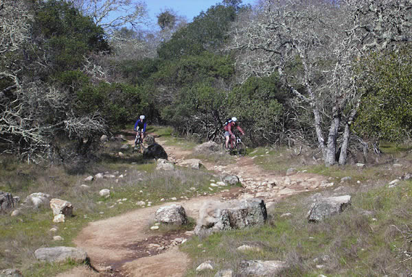
Somehow I made it through eight years living in the Bay Area without mountain biking Annadel State Park. I won't be making that mistake in the future. Annadel offers countless miles of challenging-but-not-too-challenging single-track trails through remarkably diverse and beautiful terrain. The fun quotient is huge, with long, mostly single-track loops possible without the usual killer climbs.
While Annadel is an intermediate rider's dream, advanced riders will still have fun. In fact, before the park was "upgraded" and legalized in the mid-90s, Annadel was known for its gnarly boulder-strewn downhills. Rocks are still prevalent, providing ample technical challenges and sometimes bone-jarring descents.
Annadel is a popular park where hikers, bikers and equestrians have maintained a fragile peace. Please ride with care and respect other users. |
|
Intermediate Level Trails
South Burma Trail - Moderately technical single-track through mixed forest and open meadows. Some rocky sections.
Ridge Trail - Another long stretch of single-track featuring rocky open sections and smooth, fast forested sections.
Marsh Trail - Mix of fire road and single-track through changeable terrain.
Orchard Trail - Moderately technical single-track through oak woodlands
Lawndale Trail - Fun single-track flows into and out of deep evergreen forest.
Channel Trail - Flat single-track through wooded terrain
Advanced Level Trails
Rough-Go Trail - Rocky and technical single-track through open grasslands
Cobblestone Trail - Rocky sometimes technical single-track.
Live Oak Trail - Technical, rocky single-track
Directions to trailhead(s):
Annadel State Park is located off Hwy. 12 just east of Santa Rosa. From Hwy. 101, head east on Hwy 12 for 1.5 miles. Take exit and go left on Farmer's Lane (still Hwy 12). In 0.8 miles turn right on Montgomery Drive. Drive 2.7 miles and turn right on Channel Drive. Parking is available on Channel Drive or you can drive a mile further to the park. The Lawndale trailhead is located just northwest of the town of Kenwood on Hwy 12. From Santa Rosa continue on Hwy 12 for 6.6 miles past the Montgomery Drive turn-off. Go right on Lawndale Road and follow it 1.2 miles to the trailhead parking area.
|